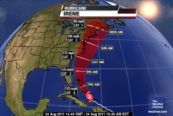
Hurricane Irene Update – As of 9 AM Thursday 8/25/11
Written on August 22, 2011 at 3:26 pm
For the 2011 Hurricane Season, danburg.com will post data on active storms that threaten our area. Obviously we are not professional Hurricane forecasters, we watch the same news and visit the same websites as you.
But with nearly a million square feet of property and 200 tenants in the area, we are very interested observers and will try to add our own insight. We provide the following as a service and take no responsibility for this content.
There are the three sites we watch most closely:
http://www.nhc.noaa.gov – National Hurricane Center (NHC)
http://www.stormpulse.com – Stormpulse – Click the button to turn “Forecast models” on
http://www.weather.com/weather/hurricanecentral – Weather Channel
Here is our latest observation:
9 AM Thursday
Everything is going as forecast, we’ll have a rainy windy day and not much else. There are some factors that can weaken the storm before it hits the northeast, but it could get pretty bad from the North Carolina to New England.
5 PM Wednesday
No change – it looks like the storm will miss us by 200 miles – a little wind and rain tomorrow – nothing more.
11AM Wednesday
As long as you’re not heading up to New York or New England, I think you’ll be ok. We can expect some wind on Thursday and Friday, and maybe some rain, but that’s about it.
5PM Tuesday
The forecast now shows the intensity a bit lower and the storm is projected to pass about 175 miles east of Boca Raton some time early Thursday morning. Tropical storm (39-73 MPH) force winds extend 205 miles from the center, so we still may feel some effects. We need to keep an eye on this, but it is looking like Irene will pass us by. The biggest question at the moment is whether schools and government offices will be open on Thursday.
11AM
The latest advisory puts South Florida out of the cone and the probability of tropical storm force winds in our area is down to 30-40%. It’s certainly looking better, but stay tuned.
9AM
Irene is shaping up to be a major category 4 storm with winds of over 135 MPH. The good news is that it may not be our problem. While a day ago, nearly the entire Florida peninsula was in the cone of uncertainty, the cone now only barely touches the our east coast. Based on data from planes that flew into the storm last night, all models are in consensus that the storm will track off the Florida coast. Still tropical storm force winds can extend 200 miles from the center of the storm. According to the NHC there is a 40-50% chance that Palm Beach County will see topical storm (39-73 MPH ) force winds. As school buses are considered unsafe in winds of over 40 MPH and the local government justifiably prefers to err on the side of caution, there is a good chance that schools will be closed on Thursday and/or Friday.
Bottom line – this is still a potentially dangerous storm. While the main threat has subsided somewhat, this should serve as a “fire drill” for your hurricane preparation. Take inventory of what you have and what you need. Make sure your cars have gas. Stock up on canned goods, propane, candles, batteries, flashlights and water. Fill up your gas tanks for your generator if you have one. You should still be prepared to hang your shutters by Wednesday. That is looking to be unnecessary but it is never a mistake to be too prepared. For your business, make sure your computers are backed up and your office and important papers are secure.
We will continue to update this post as more data becomes available.
And if you are looking for additional peace of mind in this difficult situation, please take a look at out properties at Peninsula Corporate Center, The Preserve at 7700 Congress and Holland Drive Industrial Park, all of which provide storm resistant features.


